Wersja polska poniższego artykułu
Krzysztof Borys
Weronika Borys
THE USE OF EWMAPA
for constructing and maintaining
GIS of the future
What should we understand under the term GIS of the future?
By this we should understand what we have been building in Poland as regards spatial information, what according to the law is labelled as Land Information System, and what has been the target model of functioning of spatial information in Europe; that is a model of information meant for the citizen, not only for various authorities and for the big business; we thus understand under it the "grassroots" GIS constructed from details to a generalization, enabling a smooth passage from the actual situation in land through digital maps to any level of aggregation and back. EWMAPA is a tool that can be used for that purpose, as it provides possibilities of specific construction of any objects from elements which are there on layers, and for rendering accessible the associated information relating to the real property, its surroundings or municipality to which it belongs, as available to citizens.
What is EWMAPA?
More specifically it is a relational-object-layer programme of computer graphics, enabling the maintenance of graphic database, editing of digital maps, and graphic representations; more broadly it is the basis for land information system and its management, which is made possible by a versatile set of auxiliary and descriptive programmes, and interfaces to those, thanks to which it has already been possible to implement the system in numerous administrative units and regions (one of the features of the system is that from the moment of its establishment it aims at operating for entire administrative units, not for land fragments).
EWMAPA has been functioning for some 10 years in the Polish market, originally it was restricted as to the amount of points (64 thousand), while its updated WINDOWS version provides unlimited possibilities enabling to fufil any undertaking, regardless its area or topic.
Examples of implementations
The first municipality to use EWMAPA outside the Katowice province was the municipality for RZGÓW in the Łódź province. In 1992 the land registration was modernized for that municipality, and the registration of buildings was established, while in 1993 the spatial development plan for the municipality of RZGÓW was digitally processed. Those have been used and updated until today. On the basis of the above, a common taxation of real estates was carried out in the entire municipality in 1993.
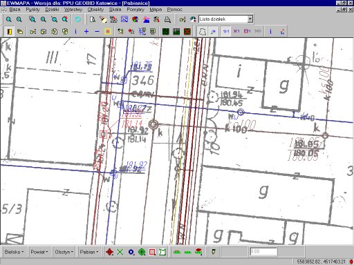
EWMAPA was then used for the establishing LIS, with various levels of advancement, on the entire pilot area of Łódź province, except for the towns of Zgierz and Łódź itself. With the aid of EWMAPA the following have been established, among others: keeping the record of public utilities in the town of Pabianice, the system for associating land and mortgage register with the registration of land and buildings in the area under the jurisdiction of the district court in Pabianice, and the common taxation of real estates in the town of Pabianice.
EWMAPA has also been used for modernizing land registers of numerous municipalities in all provinces.
Due to the wide spectrum of topics to be rendered by EWMAPA or associated and derivative programmes, the towns of Brzesko and Ostróda, and especially Olsztyn need to be recalled, where on the basis of EWMAPA a complete system of town management has been implemented, encompassing , apart from the the registration of land and buildings also the records of public utilities, spatial development plan and building inspection, charges to be levied for perpetual usufruct or lease, protection of the environment and registration of historical monuments, labelling of streets and bridges, and others.
New possibilities of using EWMAPA relate to experimental implementations:
- in Brzesko and Otwock: inspection of land use and flooding impendency, on the basis of precisely matched aerial photographs;
- in Czchów: technology for simplified combining of the graphic and descriptive part of registration of land, without identifying objects in input, but providing the possibility of identifying objects when adding the supplementary measurements;
- in the Bielsko-Biała district: delineating the areas of possible flooding, with a prognosis of how deep the water will be;
- in the Olsztyn province: establishing of regional LIS on the basis of supplementary measurements taken so far, and the existing maps of land registration.
The early days of EWMAPA
The first version, labelled 3.6, functioned only for the database of plots, constituted the module of EWMAPA that first came into being. Its main advantage lay in in efficient control of topology of plots and classification contours, unknown in other systems at that time. Later versions of the programme which appeared enabled the servicing of layers, objects, rasters, and hachures. The list of printers, plotters, and digitizers has been successively enlarged. The first version of EWMAPA for WINDOWS 95/NT was released in 1998. At present, the third version of EWMAPA for WINDOWS 95/98/NT is available. The description of the programme that follows applies to that version.
General description
The programme has been supplied with its own graphics, due to that it does not require any additional programmes to support the display. Data storage is rendered in original data structures which provide, thanks to special surface indexes, maximum read out speed for all the information or for information from the indicated area. Full archivization of data is provided, enabling to view the map status for any given day. EWMAPA stores the information on when and by whom data was added, modified, or deleted.
An important feature of the programme is that it can function in a network. Any number of users can introduce changes to the database at any given time, eg. a few people can, simultaneously, introduce modifications to the same database of plots or to the same layer, the system provides full integration of the data. The network functioning enables also to establish dispersed databases which entails that data that are visualised simultaneously may derive from various master files, as well as from different servers available in the network. EWMAPA can read user access to a given file, and if the access is of read-only type, the function of introducing any changes is automatically blocked.
The EWMAPA programme is also equipped with a module for interpolation of contour lines by means of spot heights, which enables the preparation of DTM (digital terrain model).
For geodetic applications, the option of generating sketches from a map is of importance. The sketches can be prepared in any scale on in any sheet format. It is possible to view the printout, to transpose it to the EMF/WMF format, and to prepare hybrid printouts (raster-vector ones).
Data structure
Data of the EWMAPA programme is kept in five basic structures:
- plots,
- layers,
- objects,
- hachures,
- rasters.
a/ Plots constitute a structure designed for storing information about objects on the surface, based upon the points delineating an object. Those objects cannot intersect one with another and usually cover a certain portion of land in a uniform way. Those structures most often serve the purpose of storing record plots or classification contours. It is also possible to store other surface objects, eg. precincts within the database which is the district, planned objects or other units into which the land may be divided. The EWMAPA programme is equipped with mechanisms that simplify the introduction of new plots, their updating, printing, exporting or importing. Thanks to the option of adjoining empty/void or intersecting areas may be detected.
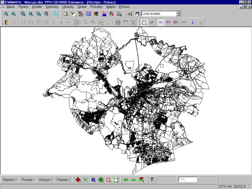
- Plots in the town of Olsztyn (nearly 100000 border points) -
b/ Layers are of technical character. Layers serve the purpose of drawing and modifying the basic elements: lines, curves, circles, words, and symbols. The shape of line and symbols is defined in a special file: a library that can be configured at the liberty of users. The EWMAPA programme is delivered with libraries of line and symbol types, in congruence with K1. Each layer has its sublayers. This enables to segregate data properly, eg. the axes of water pipelines can be on one layer yet in different sublayers, having been obtained by direct measurements, by digitizing, or indications provided by the specific trade. The layers may also be fed from the outside by ASCII files (a few different formats) or from the DXF format. All data kept in EWMAPA may also be exported to ASCII format.
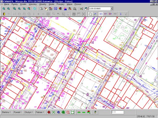
- An excerpt of map with full content -
c/ Objects have a functional character. They form the "superstructure" over layers. The idea related to objects was that under one identifier we can gather elements from various layers which make up a functional whole. An example here may be a building which on the map is composed of the ground floor, terrace, stairs and skylights. All those elements may be put together in one object and a suitable code together with identifier may be attached. EWMAPA also attends to complex objects:
- an object may be a a sub-object of another object,
- an object may include any number of sub-objects.
Such an approach to objects enables:
- creating a functional object, independent of typical geometric constructions,
- moving from the map drawing to object, which simplifies preparation of maps in accordance with requirements of cartography,
- integration of map elements - the same graphic element may be a part of several objects, eg. a common section of power supply cable,
- obtaining non-object data (eg. from the DXF file) and subsequent relating those to object,
- establishment of objects only for a limited map content, eg. registration of buildings, spatial development plan, etc., that is to the content to which the descriptive part is related, which reduces the costs of map creation.
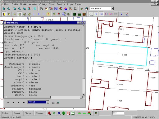
- An object: building with descriptive information obtained from EWOPIS -
d/ Hachures are a new data structure introduced in the WINDOWS version. Previous versions provided the possibility of making up hachures as result of query. In the present version, hachures may be kept as separate files, they may be also edited.
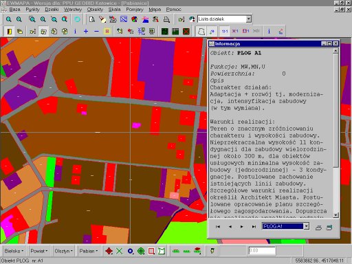
- Hachure of spatial development plan with description -
e/ Rasters are a structure enabling storing of rasters. EWMAPA serves both monochromatic and colour rasters. Monochromatic rasters may be obtained from numerous formats, and after their matching (calibration) they constitute the material not worse than the original for cartometric purposes. Oftentimes the cartometric value is even greater as the algorithms for matching (four algorithms are available) correct map errors due eg. to map contraction.
- Monochromatic raster provided with vectors -
Colour rasters are kept intwo formats: with the pallete of 256 colours and in the full colour version (16 million colours). The former type of raster is suitable for maintaining colour basic maps, record maps, topographic maps. The main advantage is the possibility of defining transparent colours, which enables ovelapping of rasters. The full colour rasters enable storing aerial photographs. The option of orthophotographic matching provides the possibility of making up full value high precision orthophotograms. It is also possible to read out the raster in a dynamic fashion, which implies that a large number of rasters may be read (eg. 50 map sections scanned with the resolution of 400 dpi), and the programme will dynamically collect data with change of scale of the image.
EWMAPA makes up and maintains height rasters. These are raster images, where every pixel of the image stores information on actual value (eg. height of the land). Only during display are those values replaced with colours, according to criteria defined by the user. This raster is suitable for monitoring of flooding impendence, assessment of the consequences of flooding, depth of flood water in any place of a given area.
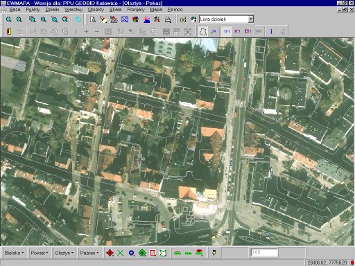
- Orthophotogram with situation layer (the town of Olsztyn) -
Interfaces
Already in the DOS EWMAPA there was a need to connect graphics with descriptive data. A mechanism of interfaces (independent programmes) served that purpose, enabling putting graphic and descriptive data side by side.
The EWMAPA programme has three categories of interfaces:
- query interface,
- reflexive interface,
- synchronizing interface.
a/ The task of the query interface is to provide information about a designated object. The interfaces may be of specialist nature, adjusted to a single database, eg. the interface to the EWOPIS programme (the descriptive part of the register of land and buildings) which, after indicating a plot of land, will display the data contained in in that system. Another example may be the interface to the OŚRODEK (centre) system, enabling obtaining a more detailed information about the survey and KERG. There are also general interfaces available for the EWMAPA programme:
- the ODBC universal interface which enables establishing a connection with any database for which the ODBC programmers are available, eg. ORACLE, MS ACCESS,
- the OPIS universal interface which enables relating description and photograph with any object,
- the DOKUMENT universal interface enabling realting scanned documents with any object (eg. by connecting the matrix points with topographic description).
b/ The aim of the reflexive interface is to indicate in the EWMAPA programme those objects which meet a certain condition. This may be done in various ways: as hachure, marker, or by changing the colour. General and specialist interfaces also exist for that type.
c/ The synchronizing interface enables the synchronization of the object database with the descriptive part, which in turn enables maintaining the compatibility between internal objects of EWMAPA and the external database.
Economic and financial prerequisites
Since entering the market in 1991, the licence for EWMAPA is made available for any number of stations/PCs in a given organizational unit, as such a multisource and technically complex system as LIS, for the establishment of which EWMAPA has been developed, must have multiple feeding sources.
The system of EWMAPA has been designed for generally available personal computers, which makes its installation possible even where there are not sufficient resources for establishing LIS.
EWMAPA has been developed for the infrastructure functioning in Poland. In contrast to numerous Western countries, that in other fields are set as examples for Poland to follow, in the domain of Land Information System Poland can be distringuished as having a relatively uniform organization and durable standards, based on technical instructions, which result in developing of certain habits that had been taken into consideration while developing EWMAPA.
That is also why the system is easy to master, that is why big enterprises such as OPGK Olsztyn undertook a mass production based on the system of EWMAPA, among other things the establishment of public utilities system in Olsztyn, taxation and registration of buildings in Ostróda and Olsztyn, where the assistance provided by the developers of the system was restricted to consultations and customizing the software for local conditions.
The technical and financial availability of the EWMAPA system enables full computerization of the state geodetic and cartographic system within the next three to four years.
For more information about the software, interfaces, prices, the company that developed the system try the Internet address: https://geobid.pl. Demo versions, demostrations in the form of slides, updated versions, technical assistance, regulations relating to geodesy can also be found there. Those who visit that page will also obtain a souvenir, a free software package with geodetic calculator.
Our address is:
PPU GEOBID
ul. Urbanowicza 37
41-500 Chorzów
phone: (32) 2410484
facsimile: (32) 2417269
e-mail:
Ten adres pocztowy jest chroniony przed spamowaniem. Aby go zobaczyć, konieczne jest włączenie obsługi JavaScript.